“Water, water nowhere and not a drop to drink”.
If you noticed the 27.4 mile day that I hiked today you might be wondering why would I hike that far? What could motivate someone to hike for 13 hours? This is New Mexico, so the answer is of course water. The story below:
We completed 20 miles yesterday, carrying three liters of water the last 5 or so miles. Three liters is enough to get thru an evening. One liter to drink between where you get the water and where you stop to camp. One liter for dinner and for the drinking in the evening and night and one liter for making breakfast and to drink until you get to the next source.
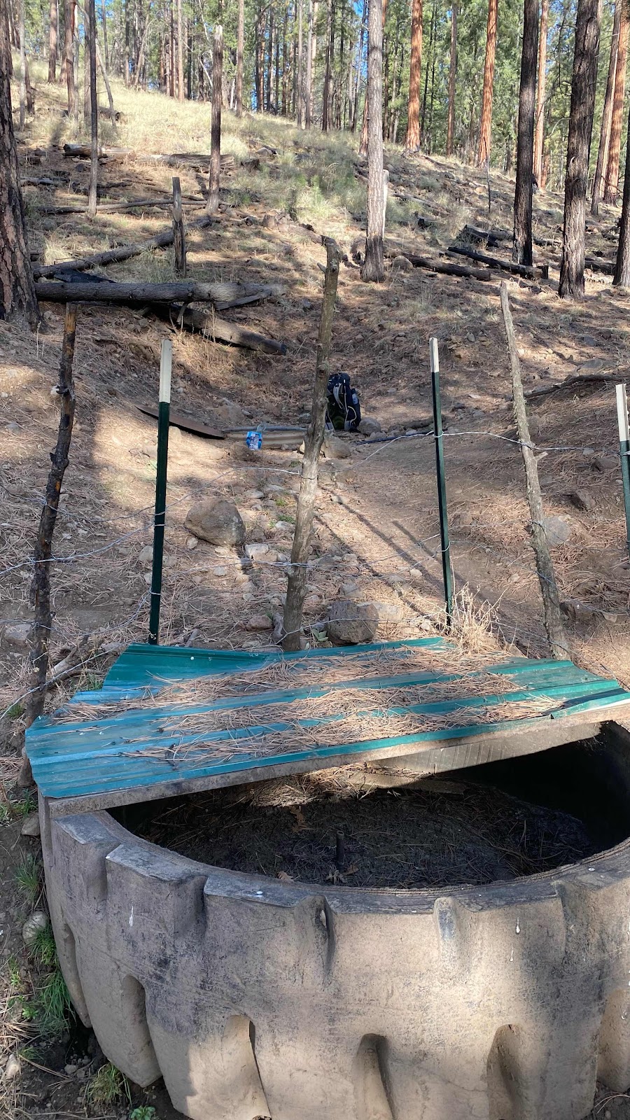
This morning the next source was five miles away, the “Dutchman Spring”. I was awake at 5:45am, had my tent down and pack ready by 6:20am. Dallas was slow to rise so I started up the road (no trail in this part, just forest service roads with zero traffic) toward the water source. I found an old tractor tire in the draw that had at one time been used as a watering trough for free range cattle, but it was dry. Behind it was a vertical piece of culvert a couple feet across with a metal lid. I pulled the lid off and saw water about 30” down. I don’t know how deep the water was. An old #10 tin of beans with the lid removed sat on the ground next to it for dipping.

I dipped out a can full and filled a liter bottle. I still had my early morning liter, bringing my total volume to two liters. Dallas soon showed up. We had looked at FarOut the night before and agreed all the water sources were sketchy, but that one of them must have tolerable water. The first was described as a seep, but all the crowd sourced comments were stating it was dry. That was five miles from the Dutchman. The next water source was a “pond” that had comments such as “your filter will hate you, but it’s drinkable” and “green and brown but it will do”. That one 7 miles from the Dutchman. The next at 9 miles had these comments:

After that, there were no other sources until 22 miles from the Dutchman.
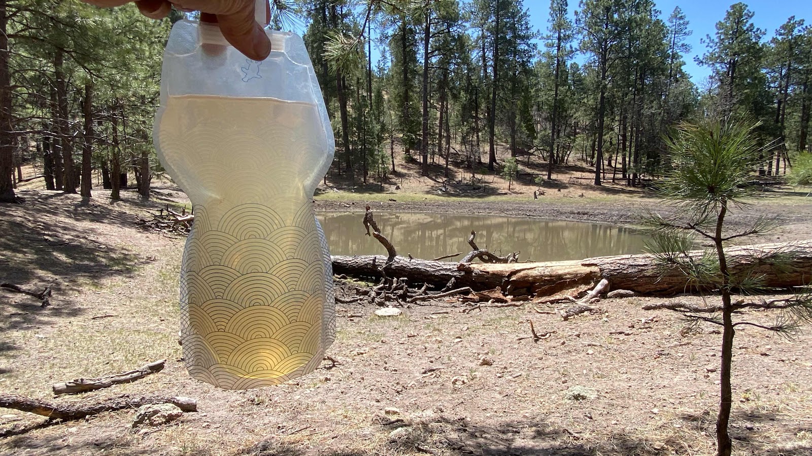
As you can see from this photo, the “pond” was a depression in the ground with some water in it that the cows walk down to and into to drink, then deficate and urinate such that it runs down into the pond.

All the ponds looked like this. My two liters carried me along for a while but I could see it would not be enough. I laid down on the log lying in the water, scooped as clean a pan of water as possible from the “pond” and poured it through my handkerchief into my bottle. Instead of the recommended 7 drops of Aqua Mira chlorine disinfectant I used 11, hoping it would kill all the organisms living in the liter I had taken.
It was my “just in case water”. I still had a liter from the Dutchman (7drops of Aqua Mira) that was clear and delicious. But, we had to get to the “good” source at 22 miles out, named the Aragon Well to have enough water for the night and the next day.
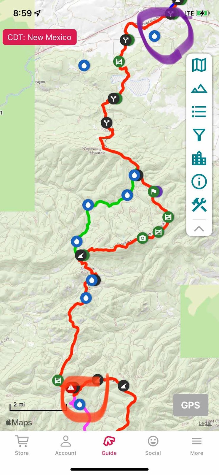
The CDT in New Mexico travels through Forest Service land and BLM land. It is thoroughly cut up with roads, so much of the “trail” is really washed out old roads. This means there are many alternate routes as there are roads everywhere. We picked an alternate (shown in green on the map, the CDT is red) because it had less elevation gain and loss and it was two miles shorter. You also can see four water sources marked on it. Three were described as dry (they were) and one was another “pond” with chocolate water surrounded with cow pies. We motored past those with our sights set on the Aragon Well.
We finished the alternate at 3:30pm. We had 7 miles to go to get to the road that accesses the Aragon, then a mile up the road.
While completing those last 7 miles my liter of Dutchman water quickly disappeared. I was very thirsty in the late afternoon sun, but to quench my thirst I only had the “pond” water left, brownish, greenish and cloudy. It was a battle between revulsion and thirst. I put off the inevitable as long as I could, but when my tongue started sticking to the inside of my mouth I had to act. I don’t know what cow piss tastes like, or I didn’t until then. Trusting the chlorine did it’s job I drank 3/4 of the “water” in that bottle. That was enough to get me to the Aragon.
We reached the road at 6:15pm. Along the way we caught up with Aaron, a mid twenties kid from Dallas who had not taken the alternate and said the CDT route really kicked his butt as it ran the ridge and was continuously climbing and descending.
I visited the bushes to do some business while Aaron and Dallas walked the mile to the Aragon. I soon caught up. We were all dragging. Tired, exhausted and thirsty. Luckily, the water here was somewhat clear, not green and with filtering or chlorination was good.
It was in a steel, open topped tank 40’ in diameter with walls about 7’ high. The owners had put fish in the tank to eat the bugs and they could be seen swimming around. There was a metal trough next to it I could stand on and reach over the side. The tank was not full, the water surface about three feet down. I could just reach down and scoop water from its surface into my cooking pot. In this manner I filled all our bottles. With five liters yet to be treated in my pack and the sun setting we moved a couple hundred yards away, found a level place in the field to pitch our tents. Once inside, I cooked dinner (spaghetti-my favorite meal and a quart of it which I happily downed), blew up my ground pad and snuggled into my sleeping bag, not necessarily in that order (I ate dinner prone in my bag-it cooled off quickly when the sun went down).
Water truly dictates how far we go each day, where we stop and for how long. If. It weren’t for cattle troughs, cattle ponds and water tanks, there would be no water for those of us attempting the CDT.
Full of spaghetti, snuggled in my bag, the temps outside dipping down through the thirties, I reviewed tomorrow’s water sources on FarOut. None. The first source was a spigot 20 miles away that crowd sourcing said was operating and had good water. Yes, there were a few cow ponds along the way, but I planned to carry three liters of water, 1 for the first ten miles while the day is cold and I don’t sweat much and two for the last ten miles when my consumption goes up with the heat of the day. Nothing is certain, so I am ready to alter plans as the day progresses. It’s an adventure!


Sorry, so tired I forgot to take a photo of the Aragon or our camping spot.
No comments:
Post a Comment